Azerbaijan is a compact country of staggering variety, making it ideal for a self-drive road trip. Turkish tourists renting a car in Azerbaijan will find everything from soaring mountains to Caspian beaches on a single itinerary. So, if you’re looking to explore rugged alpine scenery or subtropical green lowlands, there’s a destination to match your mood. Keep reading to discover some of the best landscapes in Azerbaijan.
Exploring Azerbaijan by car reveals one of the most diverse landscapes in the Caucasus. Within just a few hundred kilometers, you can drive from snow-capped peaks and ancient forests to mud volcanoes, subtropical lowlands, and Caspian Sea beaches. These eight road trips highlight the country’s most remarkable natural wonders.
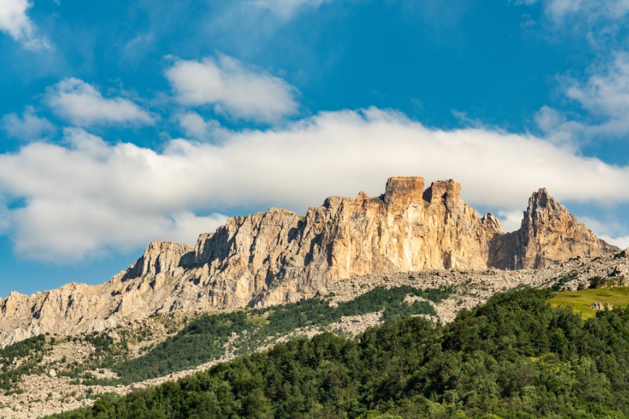
If you head north, the Greater Caucasus range offers dramatic terrain shaped by tectonic uplift and glaciation. The region’s highest peak is Mount Bazardüzü, at 4,466 metres, which forms the natural border with Dagestan. This part of Azerbaijan features sharp ridgelines, cirques, and U-shaped valleys carved by glaciers over thousands of years.
The landscape shifts quickly as you drive. Near Siyazan, the eastern foothills are semi-desert, with eroded sandstone outcrops and colorful strata caused by iron-rich soils. Moving west into Guba and Gusar, the climate becomes wetter due to orographic rainfall, feeding rivers like the Gudyalchay and Valvalachay. These valleys are lined with waterfalls, fertile meadows, and alpine pastures for summer grazing.
Further south in Ismayilli and Gabala, the mountains are cloaked in dense beech and oak forests. This area lies in the humid subtropical zone, which supports rich biodiversity. Wildlife here includes brown bears, lynx, chamois, golden eagles, and endemic plants that thrive in the cooler microclimates. The region is ideal for trekking, mountaineering, and canyon exploration, with high passes linking remote mountain villages.
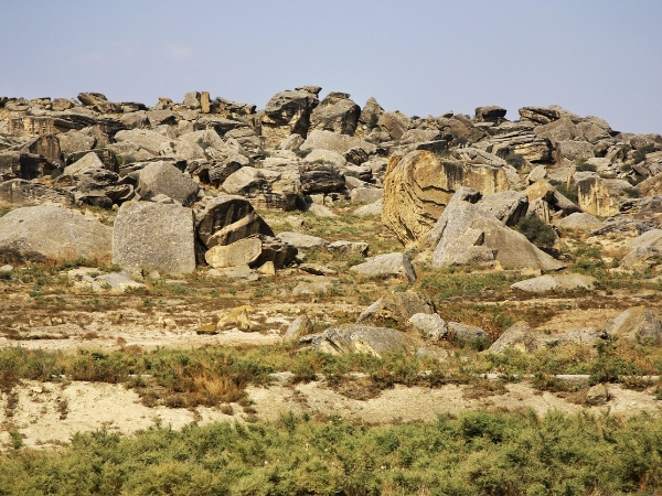
Just 64 km from Baku, Gobustan National Park is a UNESCO World Heritage site with over 6,000 petroglyphs carved into sandstone cliffs, dating from the Upper Paleolithic period through the Middle Ages. The carvings show hunting scenes, ritual dances, boats, and symbolic patterns, offering a record of more than 40,000 years of human life. Archaeologists also found stone tools and ancient dwellings, proving that the area was a major center of prehistoric activity.
The terrain is stark and rocky, formed by erosion of sedimentary layers from the Caspian basin. Huge limestone boulders and plateaus dominate the landscape, creating natural shelters that early people used for survival. The climate here is semi-arid, so vegetation is sparse, leaving the geology exposed and easy to study.
What makes Gobustan even more extraordinary are its mud volcanoes. Azerbaijan holds more than 350 features, accounting for over half of the world’s total. Many are clustered around Gobustan. Driving through the reserve, you’ll see conical mounds, bubbling mud pools, and gas vents that sometimes erupt with thick gray sludge. Some volcanoes can reach several meters in height, and eruptions occasionally shoot mud tens of meters into the air.
The Absheron Peninsula stretches into the Caspian Sea, forming a mix of semi-desert and coastal landscapes. The name “Absheron” comes from Persian, meaning “salty waters”, which reflects the many salt lakes and flats scattered across the peninsula. The inland steppe is dry and stony, shaped by arid winds, while the coast alternates between sandy beaches like Bilgah and Mardakan and rugged headlands that drop into the sea. These areas are dotted with swimming spots, resorts, and watersport facilities.
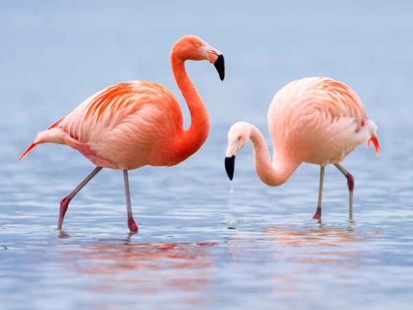
At the heart of the peninsula lies Absheron National Park, a semi-desert reserve covering over 780 hectares. It protects fragile habitats where you can spot gazelles, jackals, Caspian seals, and migratory birds. The park’s terrain is dominated by dry grasslands, sandy dunes, and low shrubs that provide food and shelter for rare wildlife. Seasonal changes bring shifts in birdlife, with flocks of flamingos and herons stopping here during migration.
In the far south of Azerbaijan, the Lankaran Lowlands sharply contrast with the arid plains further north. The region lies between the Caspian Sea and the Talysh Mountains, with a nearly subtropical climate. Moist winds from the Caspian rise against the Talysh foothills, producing high humidity and regular rainfall. This results in a fertile zone where average annual precipitation exceeds 1,200 millimeters.
The landscape is strikingly green. Driving into Lankaran, you pass tea plantations, rice paddies, and citrus groves, supported by rich alluvial soils and constant irrigation from rivers such as the Lankaran and Vilashchay. The tea grown here, mainly Camellia sinensis, is processed into strong, dark blends. Fields of rice spread across the low-lying wetlands, while orchards produce lemons, persimmons, and pomegranates. Palm trees and bamboo grow in sheltered spots. This fertile “fruit basket” region supplies much of Azerbaijan’s tea, rice, and citrus.
Rising immediately inland from Lankaran, the Talysh Mountains form a chain of rolling peaks cloaked in dense, ancient woodland. These slopes are home to the Hyrcanian Forests, one of the world’s oldest temperate woodlands and a UNESCO-listed ecosystem. The forest has survived since the Tertiary period, over 25 million years ago, when much of Europe and Asia was covered in similar vegetation. Its warm, humid microclimate has allowed many relict and endemic species to endure, making it a living museum of biodiversity.
The tree cover here is thick and diverse, with oaks, beeches, chestnuts, hornbeams, and ironwood creating a green canopy that feels almost subtropical. Underneath, mosses and ferns thrive in the moist air, while wildlife such as red deer, wild boar, lynx, and rare bird species move quietly through the valleys.
Seasonal bird migrations add to the wildlife here, making the area a great spot for birdwatching. The region is also famous for its natural hot springs with sulphur and minerals. Spa towns like Istisu and Ibadi have drawn visitors since medieval times, who come for therapeutic bathing believed to relieve joint and skin conditions.
In the northwest, the Sheki–Gabala region lies where the foothills of the Greater Caucasus meet fertile valleys. The town of Sheki, a former Silk Road stop, sits beneath thickly forested slopes and is surrounded by orchards, groves, and traditional villages. While Sheki’s historic caravanserais and palaces attract many visitors, the real charm for road-trippers is the countryside. Here, winding roads cut through a patchwork of walnut and hazelnut orchards, terraced fields, and meandering rivers.
Limestone hills and alluvial valleys shape the surrounding landscape. In Sheki, rural communities still rely on farming and nut production, with walnut forests covering large swaths of land. These woodlands provide shaded trails perfect for gentle hiking. The region also benefits from a temperate climate, with cooler summers than the lowlands, making it a comfortable escape during the hotter months.
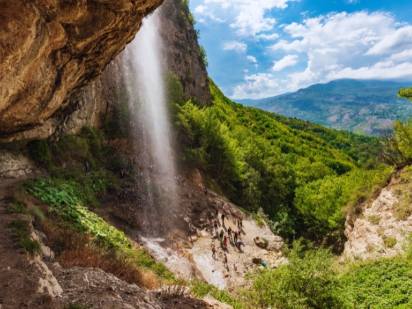
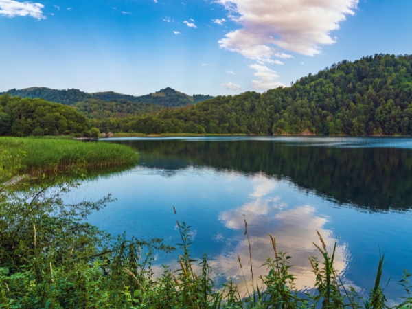
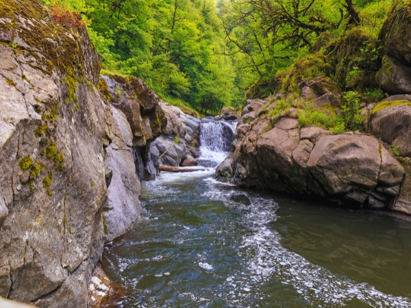
In the Gabala district, the highlights include the Seven Beauties Waterfall (Yeddi Gözəl), where streams cascade over layered cliffs into a mist-filled canyon. Not far away lies Lake Nohur, a serene body of water framed by pine-clad hills that reflect beautifully in its still surface. The area is also dotted with small resorts, forest lodges, and picnic areas, where visitors can enjoy hiking, cycling, and boating.
Running across central Azerbaijan, the Kura River Valley forms the backbone of the country’s agricultural heartland. The Kura, which rises in Turkey and flows through Georgia before crossing Azerbaijan, is the longest river in the South Caucasus at 1,515 kilometers. By the time it reaches the Caspian Sea, it has deposited thick layers of fertile alluvium, creating vast plains that support some of the country’s most important farms.
The Shirvan–Salyan plain east of Ganja and the Mil–Mughan lowlands are particularly productive. Irrigation canals fed by the Kura and its tributaries sustain vineyards, cotton fields, rice paddies, and sunflower farms. Cotton, once dubbed “white gold,” has long been a key crop here, while vineyards produce grapes used in winemaking and traditional sweets.
Turkish roadtrippers will pass endless fields, riverine woodlands, and small farming villages. Seasonal wetlands along the Kura attract waterfowl such as herons, pelicans, and ducks, making parts of the valley popular for birdwatching. Roadside restaurants serve fresh fish from the river, often grilled or prepared in local stews.
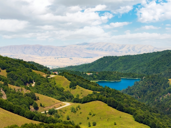
Ganja is the country’s second-largest city. It is located near the foothills of the Lesser Caucasus Mountains. The nearby Kapaz Mountain and Goygol National Park define the skyline, with alpine lakes, spruce forests, and wildflower meadows at higher altitudes. The rolling foothills around Ganja are dotted with pastures, vineyards, and orchards.
South of Ganja, the city of Mingachevir stretches across the Kura River, where a massive dam built in the 1950s created Mingachevir Reservoir, Azerbaijan’s largest artificial lake. Covering around 605 square kilometers, this body of water is important in irrigation, hydropower, and fisheries. For visitors, it has become a hub for boating, fishing, and birdwatching. Carp and catfish are commonly caught here, while migratory birds gather along the reed-fringed shores. The dam is an impressive engineering landmark, and its reservoir is sometimes called the “Caspian Sea’s little brother.”
On clear days, you can stroll along the lakeside promenade, take a boat ride across the wide expanse, or enjoy the open water views contrasting with the surrounding steppes. The area around Mingachevir also supports wetlands and grasslands, habitats for herons, ducks, and other waterfowl.
For Turkish tourists in Azerbaijan, the most practical places to rent a car are Baku and Gabala. Both have airports where it is easy to pick up your car rental.
Within short drives, you can easily reach destinations like Gobustan National Park, the Absheron Peninsula, and the Caspian coast from Baku. The road network also easily connects the capital to the Greater Caucasus Mountains in Guba and Gusar, making Baku the best starting point for first-time visitors.
You can rent a car in Gabala if you want to explore the foothill landscapes of Sheki, the Seven Beauties Waterfall, and the forested valleys that dominate the northwest. This region is popular for eco-tourism, and a car gives you the freedom to explore mountain villages, walnut groves, and scenic trails at your own pace.
Exploring Azerbaijan by road is like travelling through many countries in one trip. Within just a few hours of driving, you’ll see snowy Caucasus peaks, prehistoric rock art, burning gas hillsides, subtropical lowlands, and peaceful lakes. Each stop offers something new, from wild forests and waterfalls to sandy Caspian beaches. To make your trip smooth and flexible, rent a car in Azerbaijan with Final Rentals. Book online in advance, choose a vehicle, and pick it up at airports in Baku or Gabala when you land.